


[Publicidad]


During the first few minutes after an earthquake, there is usually a vacuum of information in which authorities are unable to determine which sites were most affected or whether or not there has been structural damage in large buildings.
This is why the Seismic Engineering Coordination at UNAM’s Engineering Institute is working on generating maps to measure seismic intensity and the overall damage throughout the national territory in real time, which could ultimately improve decision-making during times of crisis.
In order to generate these maps, Mexican scientists use information provided by several institutions such as the National Seismologic Service , operated by the Geophysics Institute .
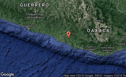
The national coverage is very diverse, though it is focused on Guerrero and Oaxaca , where the Engineering Institute is operating a monitoring network. Coverage is more deficient in the north-east.
When a tremor occurs, the mapping process is instantly triggered to identify whether or not there has been an earthquake and, according to its acceleration, the system determines whether or not a map should be generated.
dm
[Publicidad]

[Publicidad]
Más información

Mundo
Perú rompe relaciones diplomáticas con Irán; culpa al país de escalar el conflicto en Medio Oriente
Metrópoli
La Marquesa se viste de blanco por fuerte granizada; hielo cubre gran parte de la carretera en ambos sentidos

Nación
Segundo informe de Sheinbaum resalta avances en la Defensa y Marina; destacan ensamblado de 2 vehículos tácticos blindados
Tendencias
Rayos dejan 2 mil 470 muertos en México; UNAM identifica las zonas de mayor riesgo