Más Información

Ambientalistas acusan al gobierno de no atender derrame de petróleo en el Golfo de México; exigen transparencia

Sheinbaum instala comisión especial para la Ley contra el Feminicidio; acude Hugo Aguilar, ministro presidente de la Corte

Rocío Nahle supervisa limpieza de crudo en playas de Boca del Río, Veracruz; asegura que son "trazas" de hidrocarburo
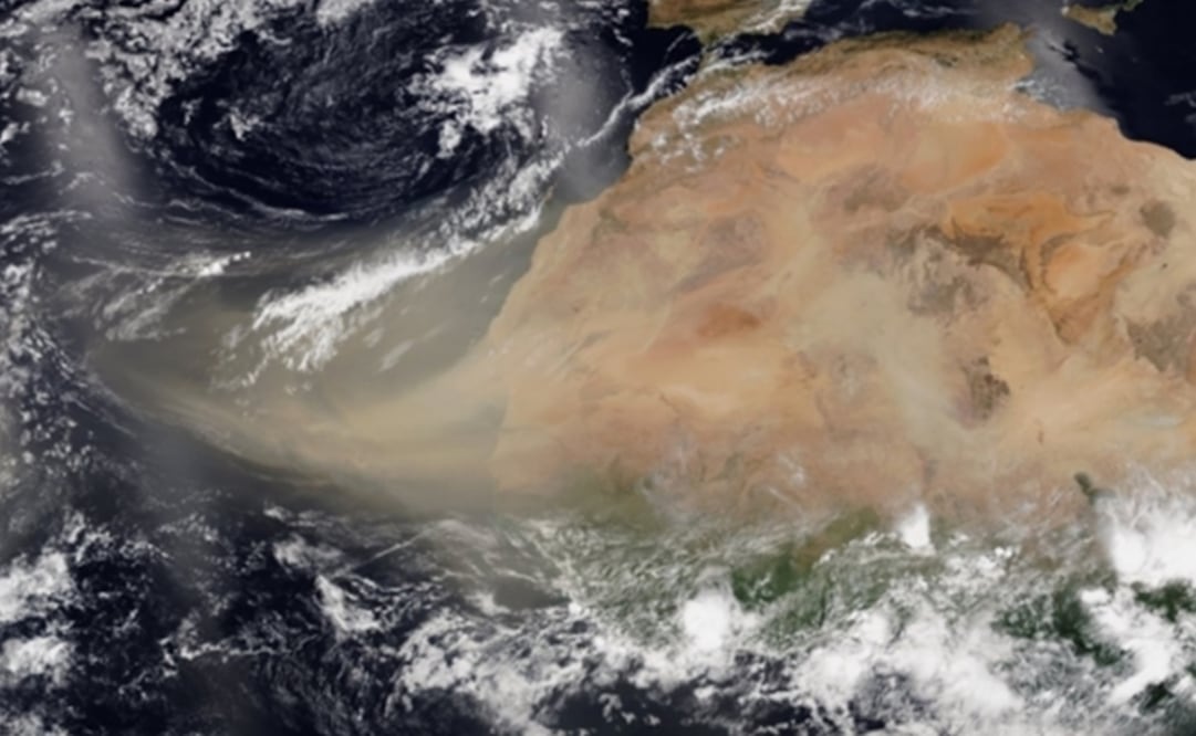
A vast cloud of Sahara dust is blanketing the Caribbean as it heads to Mexico and the U.S. with size and concentration that experts say has not been seen in half a century.
Air quality across most of the region fell to record “ hazardous ” levels and experts who nicknamed the event the “ Godzilla dust cloud ” warned people to stay indoors and use air filters if they have one.
“This is the most significant event in the past 50 years ,” said Pablo Méndez Lázaro , an environmental health specialist with the University of Puerto Rico . “Conditions are dangerous in many Caribbean islands.”
Many health specialists were concerned about those battling respiratory symptoms tied to COVID-19 . Lázaro, who is working with NASA to develop an alert system for the arrival of Sahara dust , said the concentration was so high in recent days that it could even have adverse effects on healthy people.
Recommended: What to do in case of a hurricane?
Extremely hazy conditions and limited visibility were reported from Antigua down to Trinidad & Tobago , with the event expected to last until late Tuesday. Some people posted pictures of themselves on social media wearing double masks to ward off the coronavirus and the dust , while others joked that the Caribbean looked like it had received a yellow filter movie treatment.
reported that, according to mathematical models, a vast cloud of Sahara dust is expected to arrive in the Yucatán Peninsula and that it will have a higher concentration of aerosols in Campeche , Quintana Roo , and Yucatán .
In addition, the cloud will then move through the Gulf of Mexico over the coasts of Veracruz and Tamaulipas .
The federal agencies added that the main effects in Yucatán will be the reduction of rain , an increase of temperature , foggy skies, and light clouding ; moreover, dawn and dusk will include reddish tones due to the interaction of sunrays with the dust particles.
Recommended: Hurakán, the Mayan god of storms
In a statement, the agencies said this phenomenon is common during Spring and Summer when the lack of rain is combined with strong winds in the Sahara .
These events can be traced via satellite images . This particular one has been monitored through the Atlantic Ocean and the Caribbean Sea , where it has caused a significant change in visibility.
They mentioned that when these dust clouds move through the Tropical Atlantic , they limit the development or strengthening of tropical cyclones since they are vast extensions of dry air. Lastly, they said that on June 26 , the phenomenon will move south of the U.S. and will stop directly affecting Mexican territory.
José Alamo, a meteorologist with the U.S. National Weather Service in San Juan, Puerto Rico, said the worst days for the U.S. territory would be Monday and Tuesday as the plume travels toward the U.S. southeast coast. The main international airport in San Juan was reporting only 8 kilometers of visibility.
The mass of extremely dry and dusty air known as the Saharan Air Layer forms over the Sahara Desert and moves across the North Atlantic every three to five days from late Spring to early Fall, peaking in late June to mid-August, according to the U.S. National Oceanic and Atmospheric Administration . It can occupy a roughly two-mile thick layer in the atmosphere, the agency said.
Alamo said a small tropical wave headed to the Caribbean was expected to alleviate conditions by Thursday.
On Wednesday, Tabasco’s Cilvil Protection Institute (IPCET) warned about the arrival of Saharan dust in the state by Thursday afternoon and Friday morning, so it asked citizens with breathing problems to take precautions against possible health effects .
It added that a gray and reddish fog linked to the storm will cover most part of the state and could affect people with underlying health conditions .
IPCET coordinator Jorge Mier y Terán Suárez
informed that, according to the forecast, the state will have the highest concentration of particles during the early morning and the storm is expected to leave Tabasco on the morning of June 26 bound toward the Gulf of Mexico.
He said the Sahara dust cloud is currently located at the Yucatán Peninsula and that it will mainly affect municipalities located in the regions Centro , Pantanos , and Ríos , as well as the coastline .
People with breathing issues are urged to stay home, close doors and windows, and wear face masks, for the phenomenon creates a risk of bacterias , viruses , spores , iron , mercury , and pesticides that travel with the dust, which could end in allergies and asthmatic crisis.
Elderly people
, pregnant women , and children are urged to remain inside their homes and not to do any outdoor activities to prevent any risk since the COVID-19 health emergency increases the danger of being exposed to the contamination caused by the Saharan dust plume.
Recommended: The Mexican students reforesting Yucatán's dunes
mp
Noticias según tus intereses
[Publicidad]
[Publicidad]


